The Piedmont physiographic province underlying Cary presents a geotechnical puzzle: saprolitic soils weathered from granite and gneiss can mask depth-to-bedrock transitions that standard drilling alone may miss. Electrical resistivity surveys cut through this ambiguity by mapping vertical changes in apparent resistivity, directly correlating with moisture content, clay fraction, and rock quality. In a town where rapid residential expansion west of NC-55 and commercial infill near downtown keep earthwork contractors busy year-round, knowing where competent refusal sits before mobilization saves both schedule and budget. The method proves especially useful where the water table fluctuates seasonally within the partially saturated zone, a condition common across Wake County. For projects requiring mechanical confirmation, the resistivity profile guides placement of SPT drilling boreholes at anomalous locations rather than on a rigid grid, reducing total investigation cost while improving the geological model.
A resistivity survey maps what lies between borings—the continuous profile that scattered SPT blows cannot capture on their own.
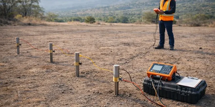
Methodology and scope
Local considerations
A mixed-use building pad off Walnut Street encountered unexpected groundwater inflow at 12 feet during a wet February, delaying foundation work by three weeks. The pre-construction investigation had relied solely on widely spaced borings that missed a lens of saturated silty sand perched above a low-permeability claystone saprolite. A VES survey performed afterward delineated the lens laterally over a 90-foot swath, showing resistivity values below 30 ohm-m where adjacent dry ground registered above 120 ohm-m. This contrast is typical of the Triassic basin sediments and weathered felsic rocks found beneath Cary’s western subdivisions. Without the geophysical snapshot, the contractor would have repeated the same surprise at the next phase. The lesson applies especially to sites near Crabtree Creek or its tributaries, where paleochannel deposits create abrupt lateral changes in drainage that conventional borings often straddle rather than intercept.
Applicable standards
ASTM D6431-18 Standard Guide for Using the Direct Current Resistivity Method for Subsurface Site Characterization, USACE EM 1110-1-1802 Geophysical Exploration for Engineering and Environmental Investigations, FHWA-NHI-16-009 Geotechnical Site Characterization (resistivity applications for transportation projects)
Associated technical services
Standard VES Depth Profiling
Single-point Schlumberger soundings to 80 ft for foundation design, septic drainfield suitability, and depth-to-rock determination on commercial lots.
2D Electrical Resistivity Tomography (ERT)
Multi-electrode profile lines for utility corridor mapping, karst feature detection in the Rolesville granite, and cut-slope moisture monitoring.
Water Table & Aquifer Characterization
Seasonal resistivity monitoring paired with groundwater level readings to delineate the saturated zone and track perched water migration during construction dewatering.
Typical parameters
Frequently asked questions
How much does a resistivity survey cost for a typical residential lot in Cary?
For a standard single-family lot under half an acre, a VES survey with two to three soundings generally runs between US$560 and US$900, depending on access conditions, target depth, and whether 2D tomography is requested. Larger commercial parcels or sites requiring multiple profile lines are priced per linear foot after a site walk.
Can electrical resistivity distinguish between saprolite and competent bedrock in the Piedmont?
Yes, it is one of the strongest applications of the method in this region. Competent granite or gneiss typically shows resistivity above 1,000 ohm-m, while water-saturated saprolite falls below 100 ohm-m. The transition zone, where corestones float in weathered matrix, produces intermediate values that guide the driller on when to expect refusal.
What surface conditions in Cary affect resistivity data quality?
Dry sandy topsoil common in the Carpenter and Green Hope areas increases contact resistance; crews address this by pre-wetting electrode stakes with saltwater solution. Buried construction debris in older subdivisions near downtown can create noise, and overhead power lines along NC-55 and High House Road require careful profile orientation to avoid electromagnetic coupling.