The saprolitic terrain around Cary doesn't always give clean answers with just borings. With bedrock depths in Wake County jumping from 20 to over 80 feet across short distances, seismic tomography becomes a practical necessity for any project that needs a continuous profile. The Piedmont residuum here is tricky—partially weathered rock can look like refusal on an SPT log but still transmit shear waves. We run both refraction and reflection lines to sort out what's actually down there. For deeper targets or when lateral resolution matters more, we can pair this with a resistivity survey to cross-check anomalies before you commit to excavation. The Town of Cary's development review process accepts geophysical data as supporting documentation, which often shaves weeks off the permitting timeline when you can demonstrate bedrock configuration without opening twenty test pits.
A single seismic line can replace four to five borings for mapping bedrock topography, which cuts investigation costs on large-footprint sites across Cary.
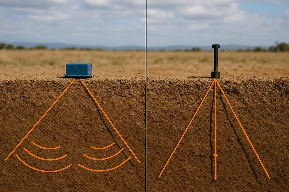
Methodology and scope
Local considerations
We deploy a 48-channel Geometrics Geode seismograph on most Cary jobs, paired with 4.5 Hz vertical geophones for refraction and 14 Hz horizontal geophones when we're after SH-wave reflection data. The biggest risk on a Piedmont site isn't the equipment—it's cultural noise. Running a line within 200 feet of the CSX tracks or during peak traffic on Kildaire Farm Road gives you a record full of garbage if you don't stack enough hits. We stack 6 to 12 blows per shot point and monitor the raw traces in real time. Refraction work assumes velocity increases with depth, which holds for most Cary profiles until you hit a fractured zone below the water table where a velocity inversion can hide a low-velocity layer. We flag those scenarios by comparing intercept times and running a blind-zone analysis. For sites within the Falls Lake or Jordan Lake watersheds where seasonal saturation fluctuates, we adjust the interpretation for the velocity pull-down effect that wet saprolite introduces.
Applicable standards
ASTM D5777-18 – Standard Guide for Using the Seismic Refraction Method, ASTM D7128-18 – Standard Guide for Using the Seismic Reflection Method, ASCE 7-22 – Site classification via VS30 when combined with shear-wave data, IBC 2021 – Chapter 16 geophysical investigation acceptance, ASTM D4428/D4428M-14 – Crosshole seismic testing (referenced when combining with borehole methods)
Associated technical services
P-Wave Refraction Tomography
The workhorse method for mapping bedrock topography and rippability across Cary subdivisions and commercial pads. We design spreads between 115 and 460 feet long, shoot from multiple offset positions to capture reverse travel-time branches, and invert the data with a starting model built from intercept-time analysis. The final velocity cross-section distinguishes soil, weathered rock, and competent gneiss with enough resolution to guide cut-and-fill decisions. This data also feeds directly into VS30 calculations for ASCE 7 site class determination when combined with complementary shear-wave measurements.
SH-Wave Reflection Profiling
When you need higher vertical resolution than refraction can deliver, or when the target is below a velocity inversion that refraction won't see, we switch to SH-wave reflection. Horizontal geophones and a cross-polarized source generate shear waves that reflect off acoustic impedance contrasts at bedding planes, fracture zones, and the soil-rock interface. Processing includes CDP sorting, NMO correction, and post-stack migration. This technique works well along Cary's greenway corridors where shallow utility conflicts limit spread length but you still need 100-plus feet of penetration.
Typical parameters
Frequently asked questions
What does a seismic tomography survey cost for a typical Cary residential lot?
For a standard single-family lot with a single refraction line and processed cross-section, the cost runs between US$2,690 and US$5,740. The spread depends on line length, number of shots, terrain access, and whether you need both P-wave and SH-wave data. Sites with heavy understory or steep drainage swales add setup time. We provide a fixed-price quote after a site visit.
Can seismic tomography tell the difference between weathered rock and competent bedrock?
Yes. In the Cary area, competent felsic gneiss typically shows P-wave velocities above 10,000 ft/s, while weathered saprolite runs 2,000 to 5,000 ft/s. We map the transition zone as a velocity gradient rather than a sharp boundary, which is more geologically realistic for Piedmont residuum. The rippability threshold commonly used by excavators—around 7,000 ft/s—falls in the middle of that gradient and we call it out explicitly on the cross-section.
How long does a seismic survey take, and what access do you need?
A single refraction line under 300 feet with 24 channels takes about two to three hours on site, plus processing time back in the office. We need a clear corridor roughly 10 feet wide for the spread, and we can work around scattered trees by adjusting geophone positions. You get preliminary results within three working days and the final signed report within a week. Access for a pickup truck and a hand-carried seismograph is usually sufficient.
Do you need borehole control to calibrate seismic results?
The reference range for this service in Cary North Carolina is US$2.690 - US$5.740. The final price depends on the project scope and volume.
Can seismic tomography detect underground voids or sinkholes in the Cary area?
Refraction tomography can miss isolated voids because it assumes velocity increases with depth, and a void represents a low-velocity anomaly that may not invert correctly. For void detection in the Triassic basin sediments east of Cary, we typically recommend combining refraction with resistivity imaging or running a parallel reflection line. The reflection method responds to the top-of-void impedance contrast and is more diagnostic for that specific problem.